Managed Geosteering Services
Selman Geo Services delivers real-time geological reporting, formation interpretation, and well placement support that helps operators maximize reservoir exposure, reduce drilling uncertainty, and improve overall well performance by using our state-of-the-art software, EarthSteer.
Directional and horizontal drilling require constant coordination between geological interpretation and wellbore placement. Small deviations can reduce reservoir contact, increase drilling time, and affect long-term well performance.
Selman Geo Services provides professional Geosteering Reporting Services that give operators, engineers, and directional drilling teams a consistent geological perspective throughout the operation. We evaluate incoming real-time drilling data, track formation changes, and communicate clear well-placement guidance.
Our objective is to help maintain the wellbore within the intended target interval, improve drilling efficiency, and navigate complex formations with greater confidence.

Industry experience supporting oil and gas operations.
Wells logged and interpreted across major producing regions.
Support for regional and multi-basin drilling programs.
Geological interpretation and drilling data monitoring.
Geosteering uses real-time geological and directional drilling information to guide a wellbore through a target formation. Selman documents each interpretation in a clear, usable format that may include formation correlation, target-window position, structural observations, directional trends, landing analysis, and well-placement recommendations.
Continuous evaluation of formation response, markers, boundaries, dip changes, and structural trends.
Correlation of active-well data with offset wells, modeled horizons, and expected stratigraphic relationships.
Tracking the wellbore relative to the target window, formation top, base, and interpreted boundaries.
Timely reporting that keeps geologists, engineers, and directional drillers aligned.
Updated geological context that supports reservoir navigation and lateral placement.
Actionable interpretation that helps reduce unnecessary corrections, delays, and nonproductive time.
From incoming drilling information to final client deliverables, Selman follows a consistent workflow designed to support timely interpretation and clear operational communication.
LWD, MWD, mud logging, survey, gamma-ray, and offset-well information.
Review incoming measurements and identify meaningful formation changes.
Compare the active well with offset wells and interpreted horizons.
Update formation picks, structural understanding, and target relationships.
Communicate practical observations that support directional decisions.
Deliver organized daily records, logs, summaries, and final geological reports.
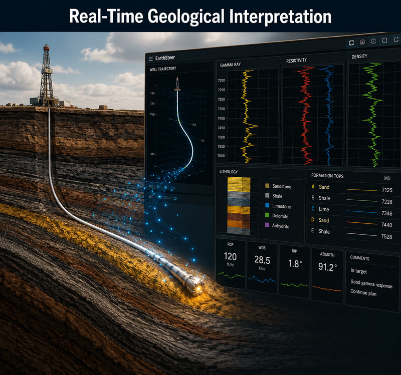
Our geologists analyze the latest drilling information as it becomes available. The interpretation process may include:
This real-time geosteering support gives the drilling team a current geological framework rather than relying only on the original pre-drill model.
Formation correlation connects the active well to nearby offset wells and the expected geological framework. Selman evaluates changes in log character, stratigraphic markers, formation thickness, and structural position to keep the interpretation current.
When actual drilling results differ from the original geological model, our reporting clearly documents the revised interpretation. This helps the team understand whether the well is approaching a boundary, crossing a structural feature, or moving away from the planned reservoir interval.

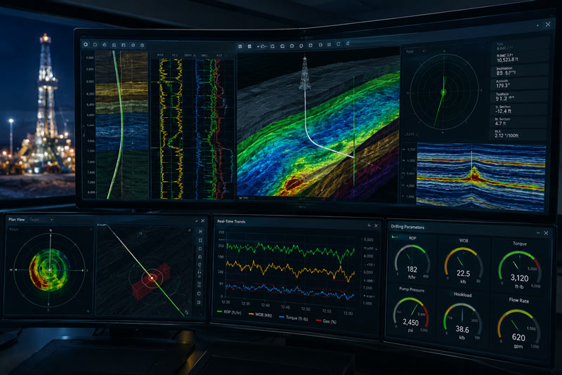
Planned, actual and projected trajectory information is reviewed relative to geological targets, landing zones and interpreted formation boundaries.
Accurate geological reporting gives engineers, geologists, directional drillers, and decision-makers a shared understanding of the well’s current position and the geological conditions ahead.
Maintain greater exposure to the productive interval.
Identify changes early and minimize avoidable drilling time.
Support wellbore positioning throughout the horizontal section.
Use geological context to protect the planned reservoir objective.
Deliverables are tailored to the operator’s workflow and may be supplied as digital reports, PDFs, visual logs, interpretation summaries, and final well packages.
Clear summaries of current position, interpretation, operational changes, and notable geological observations.
Cross-sectional views illustrating the well path relative to interpreted formations and boundaries.
Side-by-side comparisons between the active well, offsets, and interpreted stratigraphic markers.
Well-position and survey information organized for technical review and decision support.
A consolidated geological record suitable for post-well analysis and future planning.
Selman combines professional geological interpretation with EarthSteer™ to organize real-time drilling data, formation correlations, well trajectory information, and reporting deliverables in one collaborative environment.
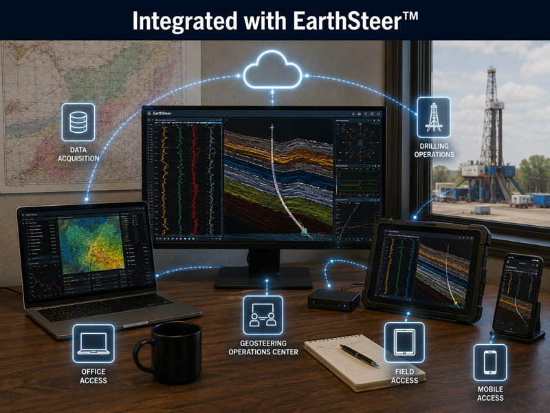
Provide current geological context for operational decision-making.
Recognize boundaries, structural changes, and interpretation uncertainty earlier.
Maintain closer alignment between the planned target and actual well path.
Limit avoidable corrections, delays, and inefficient drilling.
Protect reservoir exposure and production potential.
Give the entire drilling team access to clear, consistent reporting.
Selman combines experienced geological personnel, proprietary technology, standardized reporting, and a service-first operating model.
Decades of oilfield geological services and operational support.
Professional interpretation grounded in practical wellsite experience.
Timely updates throughout landing, lateral drilling, and total depth.
Support across major U.S. producing regions and basins.
Integrated visualization, collaboration, and reporting capability.
Responsive communication during active drilling operations.
A broad foundation of field experience across diverse geological settings.
Deliverables aligned with the operator’s technical and communication needs.
Real-time support for active drilling programs.
Flexible reporting for single-well and multi-well programs.
Landing and lateral geosteering support.
Geological interpretation aligned with trajectory decisions.
Reservoir navigation in complex and laterally variable targets.
Formation interpretation for directional geothermal drilling.
Services may include real-time geological interpretation, formation correlation, trajectory monitoring, target-window tracking, daily reporting, geosteering logs, structural cross sections, correlation panels, and final well reporting.
Depending on the project, our geologists may evaluate LWD and MWD measurements, gamma ray, directional surveys, mud logging data, offset-well information, geological models, and operator-provided reference data.
Yes. Selman can provide remote geosteering and geological reporting support using EarthSteer™ and approved real-time drilling data sources.
Yes. Our geosteering reporting services are designed for horizontal, directional, and deviated wells, including landing and lateral sections.
Reporting frequency is established with the client and may be continuous, shift-based, daily, or event-driven depending on the operating program.
Yes. Report content, formatting, distribution, terminology, and deliverables can be adjusted to support the operator’s geological, engineering, and management workflows.
EarthSteer™ strengthens visualization and collaboration, but the final workflow can be configured around the operator’s available data and reporting requirements.
Contact Selman Geo Services with the location, expected spud date, target formation, data availability, and reporting requirements. Our team will help define the appropriate scope.
Posted on Google
 heather grigsby
 Posted on Google
 Kristie FergusonWe recently used Selman Mudlogging on two wells in the Texas Panhandle, and they absolutely exceeded expectations. Their team was consistently on time, professional, and extremely reliable. With their Starlink setup, communication was seamless—no downtime, no delays, and always reachable when needed. Their daily reports were clear, timely, and dependable. Our mudlogger was highly knowledgeable and did an excellent job analyzing samples and identifying shows in new zones, which added real value to the project. The accuracy and attention to detail were outstanding. Selman’s online portal and mobile app make accessing sample analysis, uploads, and reports incredibly convenient. Everything is organized, easy to navigate, and available in real time. Overall, they were very easy to work with, extremely competent, and clearly dedicated to delivering a top-tier service. We’ll definitely be using Selman Mudlogging on future jobs. Highly recommended.Posted on Google
 Ross EvansI’d like to take a minute and provide a review of this awesome company a Permian/North Texas operator’s view point due to how happy we’ve been with working with this company. This company deserved a detailed review post! I personally have to say, that this has been my favorite logging company that has logged for us at Joint Resources and that I’ve worked with to date. I’ve been managing the mud logging operations for over 12 years at my company and have worked with numerous companies in the Permian and North Texas regions, and this company has been on point all across the board from, all the way from customer support to operations in the field as well as giving the best performing gas detection system and post well logs I have worked with. They have the most competitive pricing on the market and offer a simple pricing structure. Tom Selman does not believe in charging operators a million different fees like most other logging companies do (logger travel mileage, fees for printing post well logs, daily logger per diem/lodging fees, etc) and the base logging package is very fairly priced and beats any other operator’s pricing that we’ve used. They offer premium gas detection services as well as a first of it's kind service that I personally have never come across before. Two different things that Selman offers that I have not found another logging outfit to offer: (1) A photo log that includes BOTH high quality images of the samples AND images of the florescence shows for each of the samples recorded! This was an extremely valuable log to have post well when planning the completions! I can't even begin to tell you how cool it was to have images of the fluorescence and shows after the well, normally this is only recorded as descriptions from the Mud Logger's and having the images completely takes out the human error component/chance loggers may miss recording a good show. (2) A patented gas detection manifold that Selman offers to be welded in place at the flow line that reads the gas before it gets circulated through the possum belly. Selman included this service for free and provided the manifold set up/bull plugs and coordinated with the welder in person before the well. We tested this set up alongside the normal gas agitator set up and found it to read much higher gas readings than the agitator post-circulation readings! We’ll most definitely be using this set up on all of our future wells. This company also is equipped with Starlink services and live stream every sample live through the drilling process to its own in-house app which was really nice for the team and management to view both in the field and remotely back at the office. You get to see actual images live streamed into the app plus the mud log and gas readings which is huge. It keeps everybody in the loop. An added bonus was being able to speak firsthand with the owner Tom Selman at any time he is an extremely talented and motivated owner of this company and has instilled great standards and how his company has ran in his team goes by. Tom’s leadership at this company has really brought this team to a high standard of logging and we really appreciate that when we use them. Thanks to everyone at Selman and Associates – keep up the great work guys, Ross Evans, Geologist - Joint ResourcesPosted on Google
 Bob ThrasherThe place to go for your oil and gas geological services. Providing wellsite geological logging, geosearring, mastectomy, and geochemical services.Posted on Google
 Diana PogueFriendly and knowledgeable team, in depth data for all logging. I do recommend!Posted on Google
 Randall FordPosted on Google
 Ryan GrahamPosted on Google
 Dawn Porter
Connect your drilling team with experienced geological interpretation, clear reporting, and EarthSteer™-powered collaboration from landing through total depth.